We have recently been loaned a whole file of
documents relating to the old Lower Froyle Shop (now a private
house).
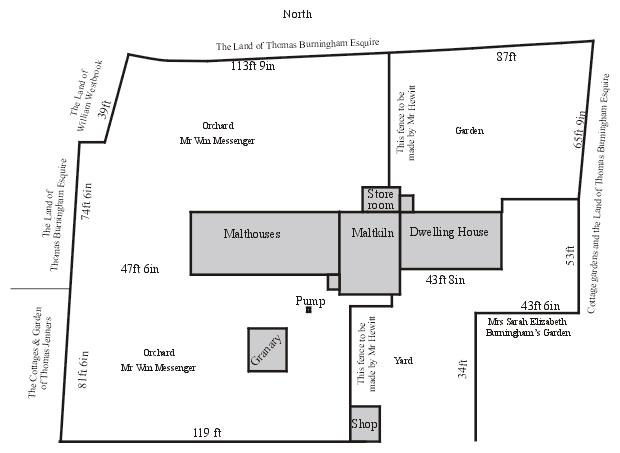
Amongst them was a plan of the area (above) dated 1837.
It is interesting to compare the changes made a few years later and
the current layout of the area. Moving your mouse over the plan will
reveal the layout as it was around 1900, clicking the map will show
the 2003 version and double clicking that should return you to the
1837 version.
Points to look out for:
- The ‘shop’ in the 1837 plan at the
edge of the road - could this have been Anne Brownjohn’s original
shop?
- In 1862 the Methodist Church was opened,
having been built in the bottom left corner of the orchard.
- The ‘Dwelling House’ had an extension on
the front that would become Lower Froyle Stores.
- A workshop was built on the right hand boundary.
- In 2003 the Methodist Church has been demolished
and replaced by a new house.
- Chapel Cottage and Orchard Cottage were
built in the 1920s in the orchard.
- It is likely that at this time the Malthouses
and granary were demolished.
- In 2008 Chapel Cottage was destroyed in a major fire and has been demolished.
We apologise for any errors in the modern map
as we don’t actually have a large scale map of Froyle available
- the most recent one we can find is 1910! To see a drawing of Mr
Hewitt’s house, follow the More link
below.
For details of names and dates we found in the documents follow The Documents link and for more about the fate of the pump follow The Pump. |